Мисия
Развитие, усъвършенстване и трансфер на методи за изследване на околната среда с интегрирано използване на технологии за дистанционно наблюдение на Земята, геоинформационни системи и наземни методи. Обучение на магистри, докторанти и специалисти в тази област.
Състав
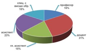
Секцията се състои от 16 научни работници и специалисти: четирима професори, трима доценти, пет главни асистенти, един асистент (докторант) и трима специалисти с висше образование (от които един е докторант). Те са с различна квалификация – географи, ландшафтни еколози, инженери, геолог и археолог.
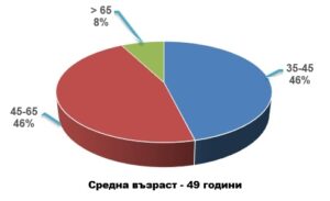
Възраст
Структура
В секцията са обособени две научни лаборатории и един научен комплекс:
![]() Лаборатория „КОСМИЧЕСКИ БИОТЕХНОЛОГИИ“ с ръководител гл. ас. Илияна Илиева
Лаборатория „КОСМИЧЕСКИ БИОТЕХНОЛОГИИ“ с ръководител гл. ас. Илияна Илиева
![]() Лаборатория „ПОЛЕВИ ПОДСПЪТНИКОВИ ИЗМЕРВАНИЯ“ с ръководител проф. д-р Георги Желев
Лаборатория „ПОЛЕВИ ПОДСПЪТНИКОВИ ИЗМЕРВАНИЯ“ с ръководител проф. д-р Георги Желев
- Валидиране на спътникови данни и продукти (земно покритие, вегетационни индекси, последствия от пожари);
- Развитие на научно-информационния комплекс за аерокосмическите полигони на територията на Р. България;
- Трансфер на технологии за дистанционно наблюдение на Земята в областта на ландшафтно-екологичната оценка на природната среда, туризма, и културно-историческото наследство;
- Оценка на развитието на земеделски култури чрез вегетационни спътникови продукти с пространствена разделителна способност 250 – 300 m;
- Геоекологично изследване на опасни природни процеси и интегрална оценка на риска за нуждите на регионалното управление;
- Провеждане на консултации и обучение на докторанти в област на висше образование: 4. Природни науки, математика и информатика, професионално направление: 4.4. Науки за Земята, научна специалност: „Дистанционни изследвания на Земята и планетите“, по която ИКИТ-БАН е акредитиран. През 2013 г. в секцията се обучават 6 докторанта.